iHikeGPS NZ : LINZ Topo Maps 9.4.5
Paid Version
Publisher Description
Unleash the navigation potential of your iPhone or iPad with iHikeGPS NZ! Turn your device into a high-performance GPS receiver with New Zealand and Australia topo maps. These topo maps have many valuable back country details to keep you informed and safe.
Even in remote areas with no cell signal, iHikeGPS NZ ensures you always know where you've been, where you are, and where you’re going. Experience the ultimate hiking companion, offering unparalleled track recording, route navigation, and accurate Estimated Time of Arrival.
iHikeGPS NZ eliminates sign-ups, ads, subscriptions and in-app purchases, making it more affordable, hassle-free and respectful of your privacy.
Discover the limitless possibilities of iHikeGPS for tramping, biking, backpacking, canoeing, kayaking, geocaching, hiking, trekking, skiing, hunting, camping, sightseeing and 4WD exploring.
TRACKS, WAYPOINTS & ROUTES
Record tracks as you walk, even in the background. View them on the map with a Trip Timer and Odometer.
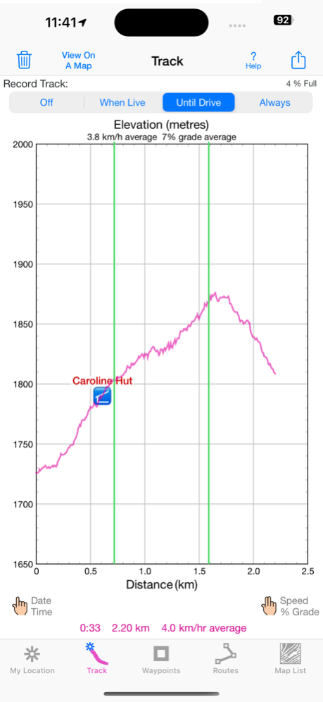
View a elevation graphs of your tracks and routes. Show date, time, average speed and % grade. Measure the area inside a closed path.
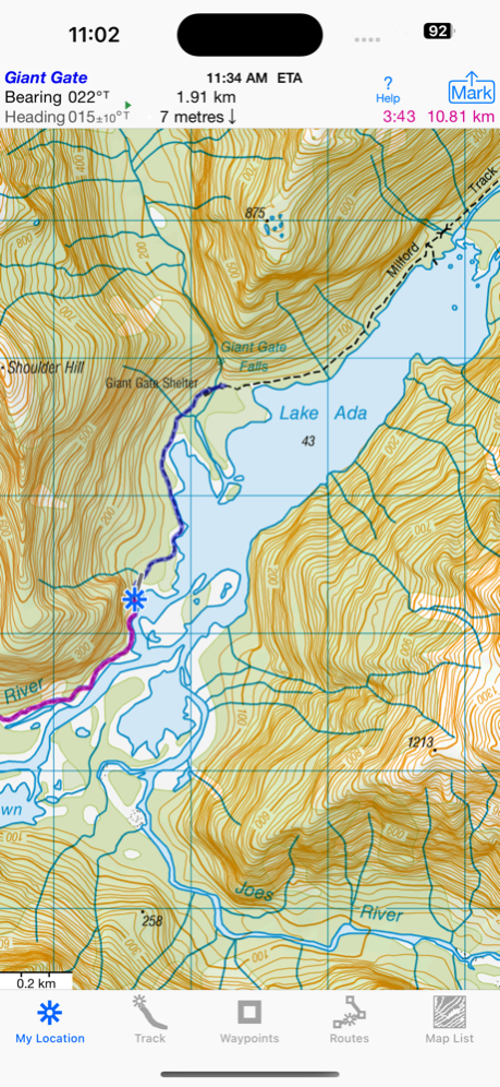
Mark waypoints precisely using topo or satellite maps, place names or addresses, geotagged photos or by projecting from a known point.
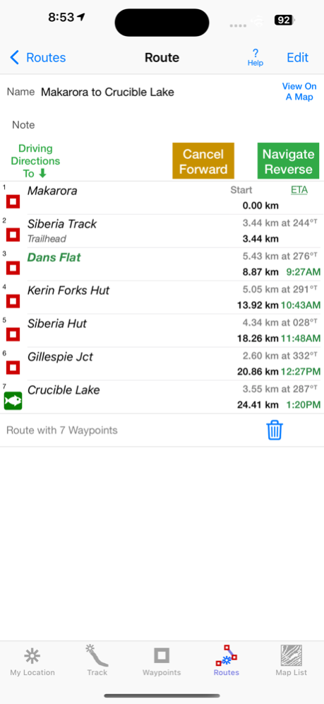
Set a quick GoTo waypoint or a full route & see the heading, direction, distance, elevation change and Estimated Time of Arrival at your destination and at intermediate waypoints along the trail.
Create customized routes using waypoints, recorded tracks, or imported GPX, KML or TCX files. Advanced route editing.
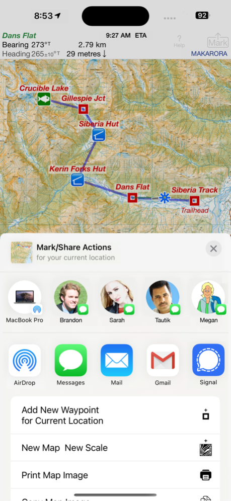
Send GPX and KML waypoint, route, track and map list files via AirDrop, eMail, Messages, or iCloud Drive.
View the sun & moon position, rise times & set times for any date and place on earth.
Send data to other apps such as Google Earth.
TOPO MAPS AT NO EXTRA COST
Official Land Information New Zealand (LINZ) 50K & 250K scale maps, including NZ off-shore islands.
Official Geoscience Australia 250K scale maps. (No smaller scale maps for Australia).
Download using WiFi or cell service. Our maps are optimized to download faster and use less storage memory. Store a few maps or all maps for both countries to use in the wilderness without cell service.
These beautiful richly detailed offline topographic map images stitch together for seamless coverage across map boundaries.
Includes map legends.
Print and Share map images overlaid with waypoints, routes and tracks.
Measure distance and direction between any 2 points.
USE THE UNITS YOU PREFER
Kilometers, Miles, or Nautical Miles.
Meters or Feet.
Degrees, Degrees/Minutes, Degrees/Minutes/Seconds, UTM, or NZTM2000 grid.
°True or °Magnetic.
HOW TOS
Comprehensive Help in the App
Online Manual on iHikeGPS.com/nz
Email developer: lwjames@iHikeGPS.com
WHAT OTHERS SAY
“This app saved my life! * * * * *
This app was downloaded, while lost in the Kaimai Ranges. GPS quickly located position, app quickly (ish) downloaded the relevant NZ topo map. From there easily identified position on the map. Outcome, life saved. And my mates who by this stage was getting all girly about it all. Best app ever!!!” - Jk9624 on the UK App Store
“I have used your ihike app for many years tramping in NZ. It is fantastic and absolutely the best off line navigation app out there.” - Paul, a internationally-known documentary film maker in Wanaka, New Zealand
DEVICE REQUIREMENTS
Use iHikeGPS on any iOS device even if you don't have a cellular data plan for it. iPhones and WiFi+cellular iPads support full navigation. WiFi-only iPads and iPod touches can view maps, but require an iOS-compatible external GPS receiver to show your location and record tracks.
Join thousands of satisfied users who rely on iHikeGPS NZ for their outdoor adventures!
Mar 7, 2024
Version 9.4.5
I use iHikeGPS on trails daily. I'm continually improving it so it will be even more useful! This version adds the ability to view a weather report for any location.
What's new in iHikeGPS NZ compared with other available New Zealand topo map apps?
• Real Navigation Power: Unlike other apps that simply display waypoints and routes on a map, iHikeGPS NZ empowers you to do real navigation to those waypoints and along those routes while receiving crucial information such as Estimated Time of Arrival, current bearing, and remaining distance and elevation gain to intermediate and final destinations. Use iHikeGPS NZ when you are on the trail and away from cell service.
• You can view an elevation graph of your tracks and your routes with waypoints, speed and % grade shown on it.
• You can create, import, edit, and navigate both on routes based on a recorded or imported path, and on routes based on a series of waypoints.
• There is never any confusion over what maps you have available offline. They are clearly listed and shown on an overview map.
• Includes 250K scale topo maps for Australia with no additional charge.
• iHikeGPS NZ' s code size is kept very small by efficient programming so in an emergency, you can download it easily even over a weak cell connection.
• The current version of iHikeGPS NZ runs on the latest devices and also on older devices with older versions of iOS , all the way back to devices such as the iPhone 6.
• Check the App Privacy section. We don't know who you are when you are using iHikeGPS NZ. We never send your current location or your recorded track to our servers. Hence we cannot and don't use your location data. We cannot and don't provide your location data to anyone else. Unlike other mapping apps that profit from using your location data in ways that do not keep it private, iHikeGPS NZ maintains the highest level of data confidentially.
About iHikeGPS NZ : LINZ Topo Maps
iHikeGPS NZ : LINZ Topo Maps is a paid app for iOS published in the Recreation list of apps, part of Home & Hobby.
The company that develops iHikeGPS NZ : LINZ Topo Maps is James Associates Inc.. The latest version released by its developer is 9.4.5. This app was rated by 1 users of our site and has an average rating of 2.0.
To install iHikeGPS NZ : LINZ Topo Maps on your iOS device, just click the green Continue To App button above to start the installation process. The app is listed on our website since 2024-03-07 and was downloaded 33 times. We have already checked if the download link is safe, however for your own protection we recommend that you scan the downloaded app with your antivirus. Your antivirus may detect the iHikeGPS NZ : LINZ Topo Maps as malware if the download link is broken.
How to install iHikeGPS NZ : LINZ Topo Maps on your iOS device:
- Click on the Continue To App button on our website. This will redirect you to the App Store.
- Once the iHikeGPS NZ : LINZ Topo Maps is shown in the iTunes listing of your iOS device, you can start its download and installation. Tap on the GET button to the right of the app to start downloading it.
- If you are not logged-in the iOS appstore app, you'll be prompted for your your Apple ID and/or password.
- After iHikeGPS NZ : LINZ Topo Maps is downloaded, you'll see an INSTALL button to the right. Tap on it to start the actual installation of the iOS app.
- Once installation is finished you can tap on the OPEN button to start it. Its icon will also be added to your device home screen.
